 한국학술지인용색인(NRF)

권호기사보기
| 기사명 | 저자명 | 페이지 | 원문 | 기사목차 |
|---|
| 대표형(전거형, Authority) | 생물정보 | 이형(異形, Variant) | 소속 | 직위 | 직업 | 활동분야 | 주기 | 서지 | |
|---|---|---|---|---|---|---|---|---|---|
| 연구/단체명을 입력해주세요. | |||||||||
|
|
|
|
|
|
* 주제를 선택하시면 검색 상세로 이동합니다.
목차 1
미시적 공간단위 행정구역의 북한 홍수 취약성 분석 = Micro-scale flood susceptibility analysis through subdivision of administrative units in North Korea / 김강민 ; 황태건 ; 조서림 ; 이유빈 ; 황철수 1
요약 1
Abstract 1
1. 서론 2
2. 선행연구 3
3. 데이터 및 연구방법 4
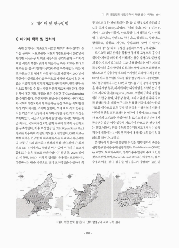
1) 데이터 획득 및 전처리 4
2) 연구 방법 6
4. 연구결과 및 토의 7
5. 결론 13
참고문헌 14
| 번호 | 참고문헌 | 국회도서관 소장유무 |
|---|---|---|
| 1 | 곽창재, 최우정, 조재웅, 2015, “돌발홍수 지수를 이용한 북한홍수 위험도 평가 - 임진강 유역을 중심으로 -,” 한국수자원학회논문집, 48(12), 1037-1049. | 미소장 |
| 2 | 국립재난안전연구원(NDMI), 2017, 재난 위험도 평가 및 대응기반기술 구축(Ⅳ). | 미소장 |
| 3 | 기상자료개방포털, 북한 강수량 자료, https://data.kma.go. kr/cmmn/main.do | 미소장 |
| 4 | 김근한, 이길상, 김오석, 최희선, 2019, “용도지역과 로지스틱회귀분석을 이용한 도시지역 확장 예측 연구,” 한국지리학회지, 8(3), 517-527. | 미소장 |
| 5 | 김금지, 2020, “북한 재난취약요인 검토를 통한 지역별 자연재난 위험도평가에 관한 연구,” 대한건축학회논문집, 36(10), 53-61. | 미소장 |
| 6 | 김성민, 서장원, 오명찬, 양아란, 송재준, 박형동, 2020, “북한광물자원 교류를 위한 GIS 기반의 북한 교통 인프라 네트워크 분석,” 한국자원공학회지, 57(2), 159-167. | 미소장 |
| 7 | 김예빈, 박형동, 2021, “침수 취약성을 반영한 북한 광산-항만간 최적 경로 GIS 분석,” 대한공간정보학회지, 29(3), 37-49. | 미소장 |
| 8 | 김정환, 김태균, 이보림, 2017, “태풍 피해유형 분석과 태풍피해예측함수 개발,” 한국방재학회논문집, 17(2), 339-347. | 미소장 |
| 9 | 김주훈, 최윤석, 김경탁, 2015, “위성 강우자료를 이용한 북한지역 홍수량 추정,” 한국지리정보학회지, 18(4), 31-42. | 미소장 |
| 10 | 남성욱, 황주희, 2018, “북한 행정구역 개편의 함의와 행정통합에 관한 연구,” 통일정책연구, 27(1), 113-142. | 미소장 |
| 11 | 박소연, 김백조, 안숙의, 2010, “북한의 자연재난 현황 및 특성,”한국방재학회 논문집, 10(3), 21-29. | 미소장 |
| 12 | 북한지역정보넷, 북한지도자료, http://www.cybernk.net/ | 미소장 |
| 13 | 손아롱, 김종필, 2019, “원격탐사와 공간정보를 활용한 미계측유역 홍수범람 해석에 관한 연구(I) - 홍수량 산정을 중심으로 -,” 대한원격탐사학회지, 35(5), 781-796. | 미소장 |
| 14 | 오삼언, 박소영, 2022, “북한의 자연재해와 기후변화 대응전략,”현대북한연구, 25(3), 181-223. | 미소장 |
| 15 | 우효섭, 김양수, 1996, “1996년 7월 임진강 유역 대홍수,” 한국수자원학회지, 29(4), 50-56. | 미소장 |
| 16 | 이사로, 오현주, 2019, “Evidential Belief Function, Weight of Evidence 및 Artificial Neural Network 모형을 이용한산사태 공간 취약성 예측 연구,” Korean Journal of Remote Sensing, 35(2), 299-316. | 미소장 |
| 17 | 이상태, 1999, “임진강유역의 수해와 항구대책,” 한국수자원학회지, 32(6), 8-15. | 미소장 |
| 18 | 이상혁, 강정은, 박창석, 2016, “베이지안 확률통계와 GIS를 연계한 기후변화 도시홍수 리스크 평가: 서울시 서초구를대상으로,” 한국지리정보학회지, 19(4), 36-51. | 미소장 |
| 19 | 조성진, 이규일, 윤승호, 문성국, 김현명, 2019, “대중교통 접근성 분석에 있어서 가변적 공간단위 문제,” 대한교통학회지, 37(6), 499-513. | 미소장 |
| 20 | 최용호, 2020, 코로나 19 사태와 북한 식량수급 동향과 전망, 한국농촌경제연구원 농정포커스, 1-17. | 미소장 |
| 21 | 통일연구원, 2017, 북한 재난협력 방안과 과제. | 미소장 |
| 22 | 한국환경정책, 평가연구원(KEI), 2008, 북한의 자연재난 취약지 추정 및 남북협력 방안 연구. | 미소장 |
| 23 | 한국환경정책, 평가연구원(KEI), 2016, 통일 대비 북한지역 자연재난 대응을 위한 자료 구축과 남북협력 방안 연구(I). | 미소장 |
| 24 | 한국환경정책, 평가연구원(KEI), 2019, 북한의 산림복원과 기후변화가 물관리 취약성에 미치는 영향과 정책방향 연구. | 미소장 |
| 25 | 홍일표, 2003, “북한의 기상재난과 재난대책,” 한국수자원학회지, 36(6), 11-114. | 미소장 |
| 26 | 황석형, 김응희, 김수환, 송경환, 김민경, 2020, “딥러닝기반 강화학습 모형 성능비교-국내 주식시장 사례연구,” 한국정보과학회 학술발표논문집, 1319-1321. | 미소장 |
| 27 | Centre for Research on the Epidemiology of Disasters (CRED), 2018, Review of Disaster Events (Supplementary Information). | 미소장 |
| 28 | Corominas, J., van Wenten, C., Frattini, P., Cascini, L., and Malet, J.P., 2014, Recommendations for the quanti-tative analysis of landslide risk. Bull Engineering Geological Environment, 73, 209-263. | 미소장 |
| 29 | Danumah, J.H., Odai, S.N., Saley, B.M., Szarzynski, J., Thiel, M., Kwaku, A., Kouame, F.K., and Akpa, L.Y., 2016, Flood risk assessment and mapping in Abidjan district using multi-criteria analysis (AHP) model and geo-information techniques,(cote d’ivoire), Geoenviron Disasters, 3(1), 1-13. | 미소장 |
| 30 | Devia, G. K., Ganasri, B. P., and Dwarakish, G. S., 2015, A review on hydrological models, Aquatic Procedia, 4(1), 1001-1007. | 미소장 |
| 31 | El-Rawy, M., Elsadek, W. M., and De Smedt, F, 2022, Flash flood susceptibility mapping in Sinai, Egypt using hydromorphic data, principal component analysis and logistic regression, Water, 14(15), 2434. | 미소장 |
| 32 | Falguni, M., and Singh, D., 2020, Detecting flood prone areas in Harris County: a GIS based analysis, GeoJournal, 85(3), 647-663. | 미소장 |
| 33 | Jung, M., Kim, J. G., Uranchimeg, S., and Kwon, H. H., 2020, The probabilistic estimation of inundation region using a multiple logistic regression analysis, Journal of Korea Water Resources Association, 53(2), 121-129. | 미소장 |
| 34 | Kang, J. Y., Aldstadt, J., Vandewalle, R., Yin, D., and Wang, S., 2020, A CyberGIS approach to spatiotemporally explicit uncertainty and global sensitivity analysis for agent-based modeling of vector-borne disease trans-mission, Annals of the American Association of Geographers, 110(6), 1855-1873. | 미소장 |
| 35 | Kim, H. I., Han, K. Y., and Lee, J. Y., 2020, Prediction of urban flood extent by LSTM model and logistic regression, KSCE Journal of Civil and Environmental Engineering Research, 40(3), 273-283. | 미소장 |
| 36 | Kim, K. M., and Park, H. J, 2017, A comparative study of fuzzy based frequency ratio and cosine amplitude method for landslide susceptibility in Jinbu area, Economic and Environmental Geology, 50(3), 195-214. | 미소장 |
| 37 | Lee, M. J., Kang, J. E., and Jeon, S., 2012, Application of frequency ratio model and validation for predictive flooded area susceptibility mapping using GIS, In 2012 IEEE International Geoscience and Remote Sensing Symposium, 895-898. | 미소장 |
| 38 | Lim, J., and Lee, K. S., 2018, Flood mapping using multi-source remotely sensed data and logistic regression in the heterogeneous mountainous regions in North Korea, Remote Sensing, 10(7), 1036. | 미소장 |
| 39 | Lim, J., Kim, K. M., and Lee, K. S., 2019, Does deforestation trigger severe flood damage at Hoeryeong City in North Korea?, Forests, 10(9), 789. | 미소장 |
| 40 | Long, Y., Lv, Q., Wen, X., and Yan, S., 2023, Bayesian logistic regression in providing categorical streamflow fore-casts using precipitation output from climate models, Stochastic Environmental Research and Risk Assess-ment, 37(2), 639-650. | 미소장 |
| 41 | Nandi, A., Mandal, A., Wilson, M., and Smith, D., 2016, Flood hazard mapping in Jamaica using principal compo-nent analysis and logistic regression, Environmental Earth Sciences, 75, 1-16. | 미소장 |
| 42 | Parvin, F., Ali, S. A., Calka, B., Bielecka, E., Linh, N. T. T., and Pham, Q. B., 2022, Urban flood vulnerability assessment in a densely urbanized city using multi-factor analysis and machine learning algorithms, Theoretical and Applied Climatology, 149(1-2), 639-659. | 미소장 |
| 43 | Pradhan, B., 2009, Flood susceptible mapping and risk area delineation using logistic regression, GIS and remote sensing, Journal of Spatial Hydrology, 9(2), 1-18. | 미소장 |
| 44 | Tehrany, M. S., and Kumar, L., 2018, The application of a Dempster–Shafer-based evidential belief function in flood susceptibility mapping and comparison with frequency ratio and logistic regression methods, Environmental Earth Sciences, 77, 1-24. | 미소장 |
| 45 | Tehrany, M. S., Kumar, L., Jebur, M. N., and Shabani, F., 2019, Evaluating the application of the statistical index method in flood susceptibility mapping and its comparison with frequency ratio and logistic regres-sion methods, Geomatics, Natural Hazards and Risk, 10(1), 79-101. | 미소장 |
| 46 | Tehrany, M. S., Pradhan, B., and Jebur, M. N., 2014, Flood susceptibility mapping using a novel ensemble weights-of-evidence and support vector machine models in GIS, Journal of Hydrology, 512, 332-343. | 미소장 |
| 47 | Voice of Korea(VOA), Article of north Korea, https://www. voakorea.com/a/3608896.html | 미소장 |
| 48 | Yusoff, S., Pradhan, B., Manap, M. A., and Shafri, H. Z. M., 2015, Regional gold potential mapping in Kelantan (Malaysia) using probabilistic based models and GIS, Open Geosciences, 7(1), 149-161. | 미소장 |
| 49 | Zeleňáková M., Blistan P., and Purcz P., 2015, Assessment of flood vulnerability in the Bodva catchment using multi-criteria analysis and geographical information systems, River Basin Manag, 8, 51-59. | 미소장 |
*표시는 필수 입력사항입니다.
| *전화번호 | ※ '-' 없이 휴대폰번호를 입력하세요 |
|---|
| 기사명 | 저자명 | 페이지 | 원문 | 기사목차 |
|---|
| 번호 | 발행일자 | 권호명 | 제본정보 | 자료실 | 원문 | 신청 페이지 |
|---|
도서위치안내: 정기간행물실(524호) / 서가번호: 국내03
2021년 이전 정기간행물은 온라인 신청(원문 구축 자료는 원문 이용)

우편복사 목록담기를 완료하였습니다.
*표시는 필수 입력사항입니다.
저장 되었습니다.
