 한국학술지인용색인(NRF)
권호기사보기
| 기사명 | 저자명 | 페이지 | 원문 | 기사목차 |
|---|
| 대표형(전거형, Authority) | 생물정보 | 이형(異形, Variant) | 소속 | 직위 | 직업 | 활동분야 | 주기 | 서지 | |
|---|---|---|---|---|---|---|---|---|---|
| 연구/단체명을 입력해주세요. | |||||||||
|
|
|
|
|
|
* 주제를 선택하시면 검색 상세로 이동합니다.
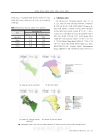
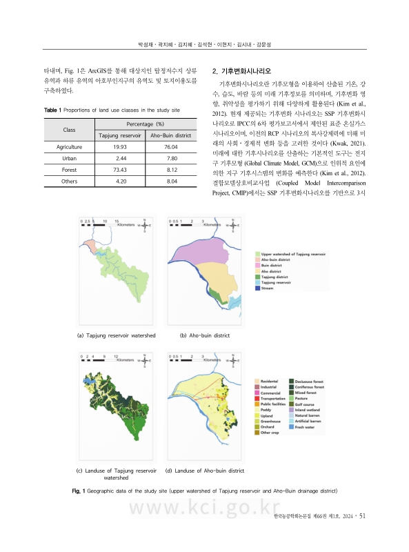
Extreme rainfall will become intense due to climate change, increasing inundation risk to agricultural land. Hydrological and hydraulic simulations for the entire watershed were conducted to analyze the impact of climate change. Rainfall data was collected based on past weather observation and SSP (Shared Socio-economic Pathway)5-8.5 climate change scenarios. Simulation for flood volume, reservoir operation, river level, and inundation of agricultural land was conducted through K-HAS (KRC Hydraulics & Hydrology Analysis System) and HEC-RAS (Hydrologic Engineering Center – River Analysis System). Various scenarios were selected, encompassing different periods of rainfall data, including the observed period (1973-2022), near-term future (2021-2050), mid-term future (2051-2080), and long-term future (2081-2100), in addition to probabilistic precipitation events with return periods of 20 years and 100 years. The inundation area of the Aho-Buin district was visualized through GIS (Geographic Information System) based on the results of the flooding analysis. The probabilistic precipitation of climate change scenarios was calculated higher than that of past observations, which affected the increase in reservoir inflow, river level, inundation time, and inundation area. The inundation area and inundation time were higher in the 100-year frequency. Inundation risk was high in the order of long-term future, near-term future, mid-term future, and observed period. It was also shown that the Aho and Buin districts were vulnerable to inundation. These results are expected to be used as fundamental data for assessing the risk of flooding for agricultural land and downstream watersheds under climate change, guiding drainage improvement projects, and making flood risk maps.
| 기사명 | 저자명 | 페이지 | 원문 | 목차 |
|---|---|---|---|---|
| 자동기계학습 TPOT 기반 저수위 예측 정확도 향상을 위한 시계열 교차검증 기법 연구 = A study on time series cross-validation techniques for enhancing the accuracy of reservoir water level prediction using automated machine learning TPOT | 배주현, 박운지, 이서로, 박태선, 박상빈, 김종건, 임경재 | p. 1-13 |
|
|
| 표준압밀시험에 의한 점토의 초기탄성계수 산정 = The estimation of initial elastic modulus of clay by standard consolidation test | 권병해, 임성훈 | p. 15-24 |
|
|
| 레질리언스 지표를 이용한 저수지 수혜구역의 전작농지 용수공급 안정성 평가 = Evaluation of water supply stability for upland crop in reservoir irrigation districts using resilience indexes | 박진석, 장성주, 이혁진, 신형진, 정수, 송인홍 | p. 25-37 |
|
|
| 건축구조기준을 활용한 농가지도형 G형 비닐하우스의 풍하중 안전성 평가 = Evaluation of wind load safety for single G-type greenhouse using Korean design standard | 이우근, 신경재 | p. 39-48 |
|
|
| 상·하류 연계 모의를 통한 기후변화에 따른 농경지 참수면적 변화 분석 = Analysis of inundation area in the agricultural land under climate change through coupled modeling for upstream and downstream | 박성재, 곽지혜, 김지혜, 김석현, 이현지, 김시내, 강문성 | p. 49-66 |
|
*표시는 필수 입력사항입니다.
| *전화번호 | ※ '-' 없이 휴대폰번호를 입력하세요 |
|---|
| 기사명 | 저자명 | 페이지 | 원문 | 기사목차 |
|---|
| 번호 | 발행일자 | 권호명 | 제본정보 | 자료실 | 원문 | 신청 페이지 |
|---|
도서위치안내: 정기간행물실(524호) / 서가번호: 국내12
2021년 이전 정기간행물은 온라인 신청(원문 구축 자료는 원문 이용)

우편복사 목록담기를 완료하였습니다.
*표시는 필수 입력사항입니다.
저장 되었습니다.
