
 대표어
대표어
 한국학술지인용색인(NRF)

권호기사보기
| 기사명 | 저자명 | 페이지 | 원문 | 기사목차 |
|---|
결과 내 검색
동의어 포함
목차
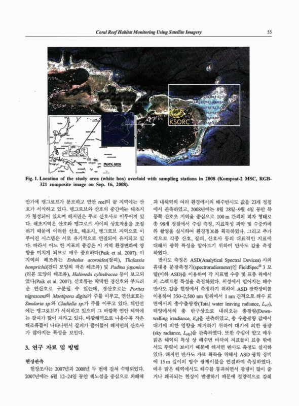
고해상도 위성영상을 이용한 산호초 서식환경 모니터링 : 축라군 웨노섬을 중심으로 / 민지은 ; 유주형 ; 최종국 ; 박흥식 1
Abstract 1
1. 서론 1
2. 연구지역 2
3. 연구 자료 및 방법 3
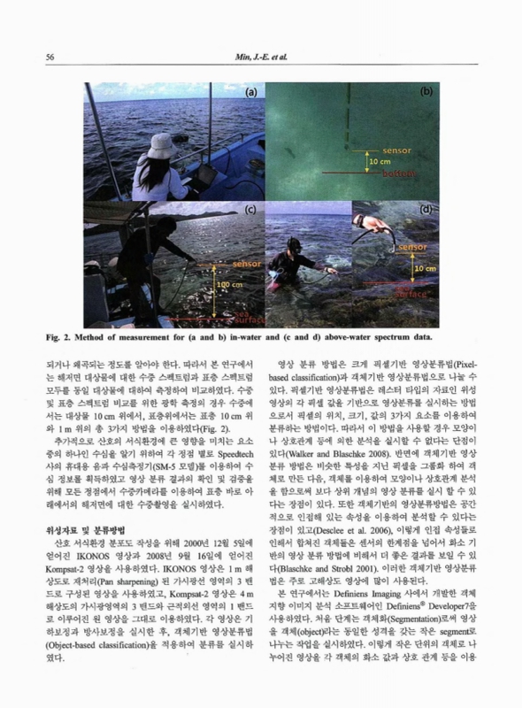
현장관측 3
위성자료 및 분류방법 4
4. 연구 결과 5
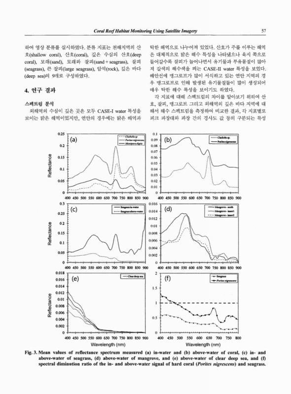
스펙트럼 분석 5
열대해역 서식환경 분류 및 모니터링 6
5. 결론 및 토의 8
사사 8
참고문헌 9
The distribution of coral reefs can be an indicator of environmental or anthropogenic impacts. Here, we present a habitat map of coral reefs developed using high-spatial satellite images. The study area was located on the north-eastern part of Weno island, in the Chuuk lagoon of Federated States of Micronesia. Two fieldwork expeditions were carried out between 2007 and 2008 to acquire optical and environmental data from 121 stations. We used an IKONOS image obtained in December 2000, and a Kompsat-2 image obtained in September 2008 for the purpose of coral reef mapping. We employed an adapted version of the object-based classification method for efficient classification of the high-spatial satellite images. The habitat map generated using Kompsat-2 was 72.22% accurate in terms of comparative
analysis with in-situ measurements. The result of change detection analysis between 2000 and 2008 showed that coral reef distribution had decreased by 6.27% while seagrass meadows had increased by 8.0%.| 기사명 | 저자명 | 페이지 | 원문 | 목차 |
|---|---|---|---|---|
| 초여름 남해광역권의 수괴별 식물플랑크톤 군집구조 특성 | 백승호 ;신경순 ;현봉길 ;장풍국 ;김현수 ;황옥명 | pp.1-13 |
|
보기 |
| 서태평양 심해 원양성 퇴적물의 탄산염 함량 변화 | 김부근 ;김여훈 ;김형직 ;형기성 ;유찬민 | pp.15-22 |
|
보기 |
| 공적분 분석을 이용한 우리나라 수입수산물의 수요함수 추정 :관세감축영향분석 | 남종오 ;김수진 | pp.23-40 |
|
보기 |
| 여름철 장목만의 환경요인과 중형동물플랑크톤 단주기 변동과의 상관성 | 장민철 ;신경순 ;장풍국 ;이우진 | pp.41-52 |
|
보기 |
| 고해상도 위성영상을 이용한 산호초 서식환경 모니터링 :축라군 웨노섬을 중심으로 | 민지은 ;유주형 ;최종국 ;박흥식 | pp.53-61 |
|
보기 |
| Effects of temperature and stocking density on the ammonia excretion rate of red seabream, Pagrus major | Dicky Harwanto ;Sung-Yong Oh ;Chong-Kwan Kim ;Victor David Nico Gultom ;Jae-Yoon Jo | pp.63-71 |
|
보기 |
| 지상 LiDAR를 이용한 만리포 해변 정밀 지형측량 및 지형 변화 분석 | 심재설 ;김진아 ;박한산 ;김선정 | pp.73-84 |
|
보기 |
| 북극의 관리체제와 국제기구 :북극이사회(Arctic Council)를 중심으로 | 진동민 ;서현교 ;최선웅 | pp.85-95 |
|
보기 |
| 번호 | 참고문헌 | 국회도서관 소장유무 |
|---|---|---|
| 1 | 권문상, 노재훈, 이미진 (2005) 남태평양 해양의 잠재력과 우리나라의 새로운 연구개발 투자 분야에 대한 고찰. Ocean and Polar Res 27(4):419-431 | 미소장 |
| 2 | 현상민, 박흥식, 김수현 (2003) 산호 골격 중의 지화학 원소:지구 기후변화 및 해양오염의 지시자 가능성. 대한지질학회지 44(1):119-131 | 미소장 |
| 3 | Multi-site evaluation of IKONOS data for classification of tropical coral reef environments  |
미소장 |
| 4 | Blaschke T, Strobl J (2001) What's wrong with pixels? Some recent development interfacing remote sensing and GIS. GeoBIT/GIS 6(1):12-17 | 미소장 |
| 5 | Desclee B, Bogaert P, Defourny P (2006) Forest change detection by statistical object-based method. Remote Sens Environ 102(1):1-11 | 미소장 |
| 6 | Hochberg EJ, Atkinson MJ, Apprill A, Andréfouët S (2004) Spectral reflectance of coral. Coral Reefs 23(1):84-95 | 미소장 |
| 7 | Jensen JR (2005) Introductory digital image processing: a remote sensing perspective. Prentice-Hall Inc, New Jersey, pp 250-251 | 미소장 |
| 8 | Joyce KE, Phinn SR, Roelfsema CM, Neil DT, Dennison WC (2004) Combining Landsat ETM+ and reef check classifications for mapping coral reefs: a critical assessment from the southern Great Barrier Reef, Australia. Coral Reefs 23(1):21-25 | 미소장 |
| 9 | Kutser T, Jupp DLB (2006) On the possibility of mapping living corals to the species level based on their optical signatures. Estuar Coast Shelf Sci 69(4):607-614 | 미소장 |
| 10 | Kutser T, Miller I, Jupp DLB (2006) Mapping coral reef benthic substrates using hyperspectral space-borne images and spectral libraries. Estuar Coast Shelf Sci 70(3):449-460 | 미소장 |
| 11 | Mumby PJ, Green EP, Clark CD, Edwards AJ (1998) Digital analysis of multispectral airborne imagery of coral reefs. Coral Reefs 17(1):59-69 | 미소장 |
| 12 | Mumby PJ, Hedley JD, Chisholm JRM, Clark CD, Ripley H, Jaubert J (2004a) The cover of living and dead corals from airborne remote sensing. Coral Reefs 23(2):171-183 | 미소장 |
| 13 | Mumby PJ, Skirving W, Strong AE, Hardy JT, LeDrew EF, Hochberg EJ, Stumpf RP, David LT (2004b) Remote sensing of coral reefs and their physical environment. Mar Pollut Bull 48(3):219-228 | 미소장 |
| 14 | Paik SG, Park HS, Kang RS, Rho HS, Lee JH (2007) Composition and configuration of tropical seagrass habitats in Chuuk Lagoon, FSM. In: Abstracts of the 2nd South Pacific Islands Regional Investigation on Tropical Marine System (SPIRITS) Workshop, Korea Ocean Research & Development Institute, Seoul, 15th Nov 2007 | 미소장 |
| 15 | Purkis SJ (2005) A “Reep-Up” approach to classifying coral habitats from IKONOS imagery. IEEE Trans Geosci Remote Sensing 43(6):1375-1390 | 미소장 |
| 16 | Purkis SJ, Myint SW, Riegl BM (2006) Enhanced detection of the coral Acropora cervicornis from satela ce imagery using a textural operator. Remote Sens Environ 101(1):82-94 | 미소장 |
| 17 | Riegl BM, Purkis SJ (2005) Detection of shallow subtidal corals from IKONOS satellite and QTC View (50,200 kHz) single-beam sonar data (Arabian Gulf; Dubai, UAE). Remote Sens Environ 95(1):96-114 | 미소장 |
| 18 | Sterckx S, Debruyn W, Vanderstraete T, Goossens R, Heijden P (2005) Hyperspectral data for coral reef monitoring. A case study: fordate, tanimbar, Indonesia. EARSel eProceedings 4(1):18-25 | 미소장 |
| 19 | Walker JS, Blaschke T (2008) Object-based land-over classification for the Phoenix metropolitan area: optimization vs. transportability. Int J Remote Sens 29(7):2021-2040 | 미소장 |
*표시는 필수 입력사항입니다.
| 전화번호 |
|---|
| 기사명 | 저자명 | 페이지 | 원문 | 기사목차 |
|---|
| 번호 | 발행일자 | 권호명 | 제본정보 | 자료실 | 원문 | 신청 페이지 |
|---|
도서위치안내: 정기간행물실(524호) / 서가번호: 국내18
2021년 이전 정기간행물은 온라인 신청(원문 구축 자료는 원문 이용)

우편복사 목록담기를 완료하였습니다.
*표시는 필수 입력사항입니다.
저장 되었습니다.
