
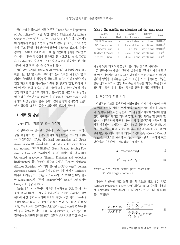
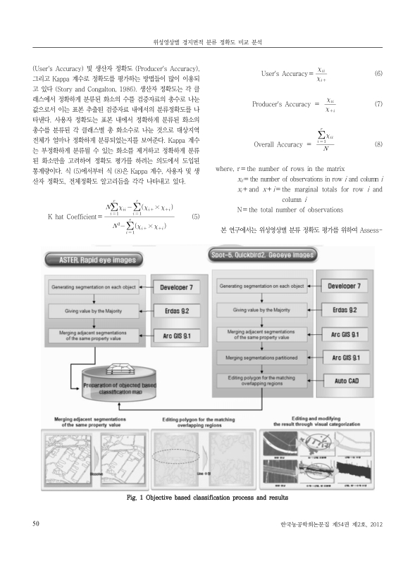
 대표어
대표어
 한국학술지인용색인(NRF)
권호기사보기
| 기사명 | 저자명 | 페이지 | 원문 | 기사목차 |
|---|
결과 내 검색
동의어 포함
| 번호 | 참고문헌 | 국회도서관 소장유무 |
|---|---|---|
| 1 | Allen, J. D., 1990. A Look at the Remote Sensing Applications Program of the Nation Agricultural Statistics Service. Journal of Official Statistics, 6(4): 393-409. | 미소장 |
| 2 | Ham, J. H. Y. C. Yoon, and S. J. Kim, 1999. Land Cover Classification and Analysis using Remotely Sensed Images Landsat TM with SPOT Panchromatic. Proceedings of 1999 Annual Conference The Korean Society of Agricultural Engineers, pp. 765-770 (in korean). | 미소장 |
| 3 | Hong, S. Y., S. G. Lim, G. S. Lee, I. S. Jo, and G. W. Kim, 2001. Estimation of Rice-Planted Area using Landsat TM Imagery in Dangjin-gun area. Journal of the Korean Society of Agricultural and Forest Meteorology, 3(1): 5-15 (in korean). | 미소장 |
| 4 | Kim, C. S. and J. H. Park, 2006. A Study on the Effective Application in Agricultural Statistics. Journal of the Korea Rural Economic Institute, 29(2): 161-176 (in korean). | 미소장 |
| 5 | Kim, S. J., 2010. A Study on Knowledge based Forest Type Classification Method using KOMPSAT- Ⅱ Image. Ph.D diss., Kyung-Il University, pp. 78-82 (in korean). | 미소장 |
| 6 | Analysis of Relationship between Vegetation Indices and Crop Yield using KOMPSAT (KOreaMulti-Purpose SATellite)-2 Imagery and Field Investigation Data | 소장 |
| 7 | Li L., C. Li, X. Zhu, and Y. Pan, 2008. Consistency analysis on paddy rice area survey with spot and TM images under the total restraint quantity. The International Archives of the Photogrammetry, Remote Sensing and Spatial Information Sciences. Vol. XXXVII. Part B8. Beijing 2008, 929-933. | 미소장 |
| 8 | Land-use Mapping and Change Detection in Northern Cheongju Region | 소장 |
| 9 | Statistics Korea, 2009. Remote Sensing Method Development by Aerophoto Utilization for the Statistics of Agriculture, 118-125 (in korean). | 미소장 |
| 10 | Story, M. and R. Congalton, 1986. Accuray Assessment: A User's Perspective. Photogrammetric Engineering& Remote Sensing, 52(3): 397-399 | 미소장 |
| 11 | Visual Learning Systems, 2002. User Manual : Feature Analyst Extension for ArcView/ArcGIS, Missoula, MT : Visual Learning Systems. | 미소장 |
*표시는 필수 입력사항입니다.
| 전화번호 |
|---|
| 기사명 | 저자명 | 페이지 | 원문 | 기사목차 |
|---|
| 번호 | 발행일자 | 권호명 | 제본정보 | 자료실 | 원문 | 신청 페이지 |
|---|
도서위치안내: 정기간행물실(524호) / 서가번호: 국내12
2021년 이전 정기간행물은 온라인 신청(원문 구축 자료는 원문 이용)

우편복사 목록담기를 완료하였습니다.
*표시는 필수 입력사항입니다.
저장 되었습니다.
