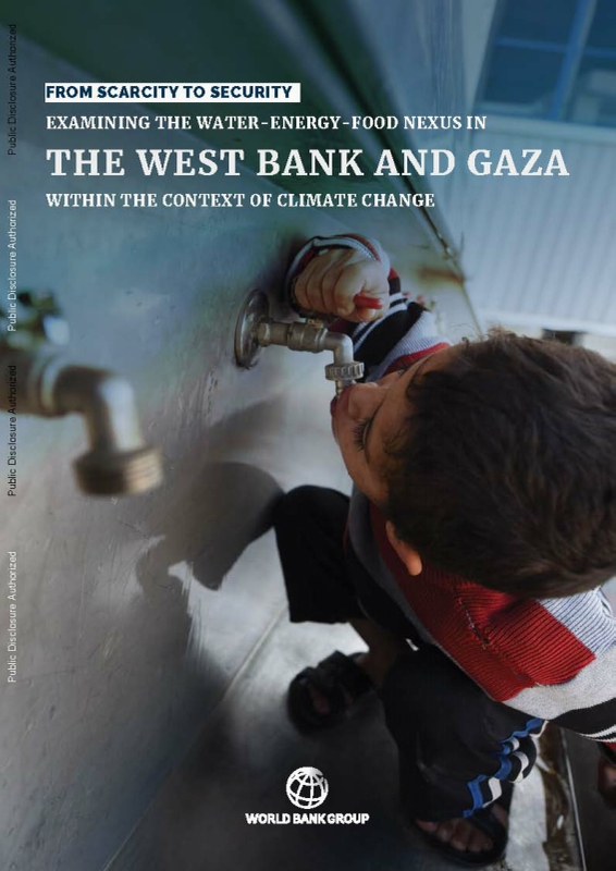
 https://documents.worldbank.org/en/publication/documents-reports/documentdetail/099072225130519995


권호기사보기
| 기사명 | 저자명 | 페이지 | 원문 | 기사목차 |
|---|
| 대표형(전거형, Authority) | 생물정보 | 이형(異形, Variant) | 소속 | 직위 | 직업 | 활동분야 | 주기 | 서지 | |
|---|---|---|---|---|---|---|---|---|---|
| 연구/단체명을 입력해주세요. | |||||||||
|
|
|
|
|
|
* 주제를 선택하시면 검색 상세로 이동합니다.
Title page 1
Contents 4
FOREWORD 8
ACKNOWLEDGMENTS 9
ABBREVIATIONS AND ACRONYMS 10
EXECUTIVE SUMMARY 12
CHAPTER ONE. INTRODUCTION 22
CHAPTER TWO. THE CLIMATE CONTEXT IN THE WEST BANK AND GAZA 30
THE CONTEXT 32
HISTORICAL CLIMATE TRENDS 33
FUTURE CLIMATE PROJECTIONS 38
THE POLICY RESPONSE 46
REFERENCE 51
CHAPTER THREE. THE WATER-ENERGY-FOOD NEXUS 52
STRATEGIC PILLARS FOR IMPROVING RESILIENCE 54
THE WATER SECTOR 58
Water Resources 59
Water Supply 67
Future Water Demand 76
Reconciling Supply and Demand and Increasing Resilience 89
THE ENERGY SECTOR 96
Energy Resources 98
Energy Demands 101
Bridging Supply and Demand 110
THE AGRICULTURE SECTOR 117
Agrifood Sector Overview by Production System 117
The Water and Energy Footprints of Agriculture 120
Building the Agrifood Sector's Resilience to Climate Change 126
REFERENCES 130
CHAPTER FOUR. CLIMATE IMPACTS 134
CHAPTER FIVE. PRIORITIZING INVESTMENTS AND POLICIES AND FINANCING 140
INVESTING IN THE NATIONALLY DETERMINED CONTRIBUTIONS (NDC) 142
INVESTING IN THE WEF NEXUS 143
REFERENCE 155
CHAPTER SIX. THE ROAD AHEAD 156
ANNEX A. INVESTMENT NEEDS IN THE WATER-ENERGY - FOOD NEXUS 162
ANNEX B. WEST BANK AND GAZA CLIMATE CHANGE IMPACT ON WATER DEMAND MODEL 170
Tables 6
Table 2.1. Historic Climate Trends in the West Bank and Gaza 34
Table 2.2. West Bank and Gaza Data Snapshot: Summary Statistics 35
Table 2.3. CMIP6 Ensemble Projection Anomalies for Annual Mean Temperature 44
Table 2.4. CMIP6 Ensemble Projection Anomalies for Annual Mean Precipitation 45
Table 2.5. NDCs Relevant to WEF Nexus 48
Table 3.1. Available Water Resources, 2020 60
Table 3.2. Interim Water Allocations as per the Oslo II Agreement 61
Table 3.3. Municipal Water Supply for the Year 2020 70
Table 3.4. Projected Water Demand Based on the National Water and Wastewater Policy and Strategy 77
Table 3.5. Estimated Available Resource from Wadis in the West Bank 92
Table 3.6. Energy Demand Forecast for Areas of Service in the West Bank 102
Table 3.7. Energy Demand Forecast in Gaza 103
Table 3.8. Evolution of Areas (ha) of Agricultural Crops in the West Bank and Gaza, 2010-20 118
Table 5.1. Proposed Policy Levers to Improve Resilience Along the Water-Energy-Food Nexus 148
Figures 5
Figure ES.1. Water Supply by Source and Demand in the West Bank and Gaza under Three Scenarios 16
Figure ES.2. Energy Requirements for Water Production by Source in Each Scenario 17
Figure ES.3. Gross Domestic Product Projections under Three Scenarios 18
Figure 1.1. Interlinkages at the Nexus of the Water, Energy, and Food Sectors 25
Figure 2.1. Average Annual Temperature Trend Analysis for Jenin, Nablus, Jericho, and Hebron, 1997-2021 36
Figure 2.2. Annual Rainfall Trend Analysis for Jenin, Nablus, Jericho, and Hebron, 1997-2021 36
Figure 2.3. Average Annual Mean Temperature versus Average Annual Mean Precipitation, 2015-50 46
Figure 3.1. Water per Capita, Dam Capacity per Person, and Gross Domestic Product 63
Figure 3.2. Actual Water Imports, 2008-20 65
Figure 3.3. Agricultural and Municipal Consumption in the West Bank and Gaza, 2010-20 67
Figure 3.4. Water Services Coverage, 2015-20 69
Figure 3.5. Sanitation Coverage, 2015-20 71
Figure 3.6. Financial Context of the Palestinian Water Sector 73
Figure 3.7. Trend in Palestinian Authority Revenues Deducted through Net Lending 74
Figure 3.8. Institutional Arrangements in the Water Sector in the West Bank and Gaza 75
Figure 3.9. Institutional Arrangements after Full Implementation of the Water Reform 76
Figure 3.10. Water Demand Projections under Each Scenario 80
Figure 3.11. Water Demand Projections Reflecting Different Levels of Consumption 81
Figure 3.12. Water Supply and Demand under the Continued Fragility Scenario 83
Figure 3.13. Water Supply and Demand under the Increased Resilience Scenario 85
Figure 3.14. Water Supply and Demand under the Toward Sustainability Scenario 87
Figure 3.15. Potential Water Savings and Investment Needs for Nonrevenue Water Reduction 91
Figure 3.16. Main Sources of Electricity in the West Bank and Gaza, 2015-21 96
Figure 3.17. Electricity Generation by Source in Israel, 1990-2021 98
Figure 3.18. Energy Required to Produce One Cubic Meter of Water 103
Figure 3.19. Energy Demands of Water Production by Scenario 104
Figure 3.20. Energy Requirements of Groundwater Abstraction 105
Figure 3.21. Energy Requirements of Desalination 106
Figure 3.22. Energy Requirements of Wastewater Treatment 108
Figure 3.23. Energy Needs of the Water Sector in Gaza 113
Figure 3.24. Renewable Energy Framework Proposed by Juaidi et al. (2022) 114
Figure 3.25. Agricultural Demand versus Agricultural Supply in the West Bank 123
Figure 3.26. Agricultural Demand versus Agricultural Supply in Gaza 124
Figure 3.27. Expected Wastewater Reuse versus Reuse Needed to Meet Demand in the Toward Sustainability Scenario 124
Figure 3.28. Mix of energy sources in the agriculture sector in the West Bank and Gaza 125
Figure 4.1. Gross Domestic Product Projections in Three Scenarios 138
Figure 4.2. The Gap between Water Supply and Demand, with and without Considering the Impacts of Climate Change, in Each Scenario 139
Figure 5.1. West Bank and Gaza's NDC Funding Gap (US$2.7 Billion) by Sector 142
Boxes 26
Box 1.1. IMPACTS AND UNCERTAINTY ASSOCIATED WITH THE CONFLICT THAT BEGAN IN OCTOBER, 2023 26
Box 2.1. SHARED SOCIOECONOMIC PATHWAYS 39
Box 3.1. THE POLITICS OF PAYING FOR WATER IN THE WEST BANK AND GAZA 72
Box 3.2. THE ROLE OF PUBLIC AWARENESS IN THE CONSERVATION OF WATER RESOURCES 94
Box 3.3. UNLOCKING RENEWABLE ENERGY POTENTIAL IN AREA C 100
Box 3.4. FLOATING PHOTOVOLTAIC SOLAR GENERATION FOR DESALINATION 107
Box 3.5. THE ASSOCIATED WORKS PROJECT 111
Box 3.6. THE GREEN BLUE DEAL 116
Box 3.7. GAZA'S COASTAL AQUIFER 128
Box 4.1. THE ECONOMIC MODELING 137
Box 5.1. CIRCULAR WATER ECONOMY IN THE JORDAN VALLEY 145
Box 5.2. RAPID DAMAGE NEEDS ASSESSMENT FOLLOWING THE 2021 CONFLICT IN GAZA 151
Maps 7
Map 3.1. West Bank Land Categories after the 1996 Interim Agreements between Israel and the Palestine Liberation Organization 55
Map 3.2. Coastal and Mountain Aquifers and the Jordan River 59
Map 3.3. Nitrate and Chloride Contours, 2017 66
Map 3.4. Normal Direct Irradiation in the West Bank and Gaza 99
Map 3.5. Crop Map for Gaza in 2020 (Relatively Wet Year, 688 mm) and 2021 (Relatively Dry Year, 500 mm) 120
Map 3.6. Crop Map for the West Bank in 2022 (Average Rainfall Year, 628 mm) 120
Box Maps 7
Map B5.1.1. (Omit) 145
Annex Figures 5
Figure B.1. Estimation of the water balances 173
Figure B.2. Decision tree for the Water balance estimate 174
*표시는 필수 입력사항입니다.
| 전화번호 |
|---|
| 기사명 | 저자명 | 페이지 | 원문 | 기사목차 |
|---|
| 번호 | 발행일자 | 권호명 | 제본정보 | 자료실 | 원문 | 신청 페이지 |
|---|
도서위치안내: / 서가번호:

우편복사 목록담기를 완료하였습니다.
*표시는 필수 입력사항입니다.
저장 되었습니다.
