
 대표어
대표어

권호기사보기
| 기사명 | 저자명 | 페이지 | 원문 | 기사목차 |
|---|
결과 내 검색
동의어 포함
[표지]
목차
기조연설 1 : River and Estuary Observatory Network(REON) : A Cyber Infrastructure for Providing near Real-time Support for Water Resources Management / James s. Bonner 3
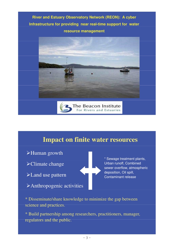
Impact on finite water resources 4
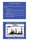
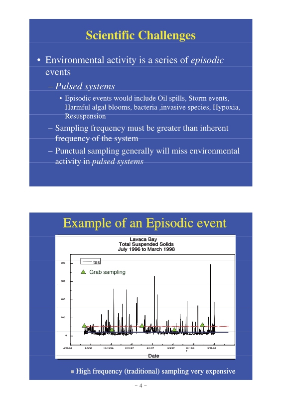
Scientific Challenges 5
Example of an Episodic event 5
Paradigm Shift 6
Examples of smart Sensors 7
Images from New FlowCytometer NSF-MRI Project 7
In-situ Acoustic Sensors 8
River and Estuary Observatory Network (REON) 8
Fixed Robotic Platforms 9
Mobile Platforms Acrobat 9
HF-Radar System on Remote Platform 10
Existing Cyber Infrastructure to disseminate data in near real-time 10
Interoperability 11
Observational Datasets 11
River and Estuary observation network 12
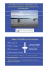
Hudson River Dredging 12
Hudson River Dredging Project 13
Hudson River Dredging: Where and How Much 13
Turbulent Diffusion Characterization 18
Strong storm event 18
Tidal forces control natural aquatic system's dynamics 19
Example datasets from May 24,2010 (Denningpoint, Beacon, NY) 20
Tidal forces dominate the particle dynamics at Beacon, NY during g strong storm event on October 21
Vertically-averaged north component of water current and particle concentration from September 30 to October 07,2010 22
Long-term monitoring datasets : Conductivity variation at Denningpoint, Beacon, NY during 2010 deployment 23
Examples datasets from Mobile monitoring platform 23
Example datasets from the Cruise made on September 24, 2009 24
Example datasets from the Cruise made on June 01, 2010 25
Technology Development 26
Meteorological Monitoring 29
Integrated hydrologic and watershed monitoring plan Coupled hydrologic (watershed) modeling 30
Conclusions: Vision for REON 30
기조연설 2 : 우리나라의 수자원ICT 현황 및 전략 / 김계현 32
I. ICT 기반 수자원관리 개요 34
1. 정보기술 발달과 수자원 정보화 34
2. ICT 기반 수자원관리란? 35
3. u-수자원관리 필요성 35
4. 추진 비전 및 목적 36
II. u-수자원관리 구현 핵심 기술 36
1. GIS (지리정보시스템) 37
2. RS(원격탐사) 37
3. GPS(범세계 위치결정시스템) 38
4. LBS(Location Based Service) 38
5. 유비쿼터스 39
6. RFID(Radio Frequency IDentification) 40
7. USN(Ubiquitous Sensor Network) 40
8. IP-USN(Internet Protocol Ubiquitous Sensor Network) 41
III. u-수자원관리 구축 현황 41
1. 국외 사례 42
2. 국내 사례 47
IV. 한국수자원공사 추진 현황 52
1. 수문관측 분야 52
2. 시설물관리 분야 57
3. 활용시스템 분야 58
V. 추진 전략 60
VI. 결론 66
Session 1 : 수재해관리와 ICT 68
4대강 사업 후 국가 홍수재해 대응 전략 / 김창완 68
4대강 살리기 마스터플랜 69
홍수위험관리 80
구조물 대책의 한계(미국의 제방정책 변화) 83
유럽의 홍수방어 정책 91
메콩델타(Mekong Delta) 94
네덜란드 사례 95
영국 사례 97
미국 사례 98
홍수와 더불어 살기 100
일본의 홍수재해관리 기술현황-Hydroinformatics for flood risk mitigation in Japan- / Keigo Nakamura 102
Increase of torrential rain 104
Heavy rain over 1000mm 104
Torrential rain in 2008 105
Hydroinformatics (ICT for river management) in Japan 105
Monitoring (Water and Rain gauging by telemeter) 106
Telemetry gauging station in Japan 106
26 rain radars (C band) operated by MLIT 107
17, 219 CCTV network for monitoring 107
Online data center of comprehensive river information 108
Data Contents: Real time hydrological data 108
Establishing stronger systems to gather and analyze information 109
Provision of River information by PC or mobile phone 109
Publication of flood hazard maps 110
"On-site hazard" map indicated, e.g. assumed flood water depth 110
"On-site hazard map" (2) 111
Recent activities on hydroinformatics 111
X-band multi-parameter rain radar for torrential rain 112
Actual Observation Samples with X-Band MP Radar (17:00 to 21:30) 112
Observation Samples with X-Band MP Radar (July 5, 2010 Itabashi Heavy Rain) 113
Difference between Conventional Radars and X-Band MP Radars 113
Precise runoff analysis using distributed models 114
Highly-Accurate Runoff Analysis based on Distributed Models 114
Distributed model with X band MP radar improves flood predicti 115
Real-time data collection of Flooding Areas 115
Real-time data collection with citizens and private sectors (Nagoya) 116
Real-time data collection of flooding areas using sensors (Yokohama) 116
Flood sensor installation at the subsided area by Great eastern Japan Earthquake 117
Flood sensor installation at the subsided area by Great eastern Japan Earthquake 117
Real time flood forecasting System 118
Output Image of Risk Level Assessment 119
Flood forecasting center (since April of 2009) 120
Common modeling platform for Water-related software (CommonMP) 120
Overview of CommonMP 121
Publication of CommonMP Ver1.0 (March 31, 2010) 121
Display of Analysis and Results Based on CommonMP 122
Display/Editing Functions Based on CommonMP-GIS 122
Terrestrial Digital Broadcasting in Kyushu Region (July 20, 2010) 123
NHK Data Broadcasting Screen (Example) 123
중국의 홍수재해관리 기술 현황 -Flood Disaster Management Technology in China- / Yicheng Wang 125
1. Topographic Characteristics 127
2. Climate Features 128
3. Rivers and Major River Basins in China 130
4. Flood Characteristics and Flood Disaters 131
5. Structural and Nonstructural Measures in Flood Disaster Management 135
6. Emerging Problems of Flood Disaster Management 139
6. Past Successful Experiences and Future Measures in Flood Disaster Management 140
6. A Case Study: Flood Disaster Management in the Yangtze River 143
차세대 홍수방어기술 개발 추진 현황 -Development of Flood Defense Technology For Next Generation in Korea- / 한건연 157
Climate Change (Typhoon) 159
Climate Change (Rainfall) 159
Cliamte Change (Sea Level Rise) 160
Climate Change (Ocean Temp) 160
Recent Flood Damages ('02-Rusa) 161
Recent Flood Damages ('03-Maemi) 161
Recent Flood Damages ('06-Heavy Rainfall) 162
Recent Flood Damages ('07-Nari) 162
Recent Flood Damages ('09-Heavy Rainfall) 163
Flood Damages in Korea 163
WAMIS 165
WINS 166
RIMGIS 166
Water Management System 167
Outline of iFLOOD Project 167
Target Statistics 168
Development Contents 168
Current Results on iFLOOD Project 170
Research Strategies 179
Operation Plan 180
Summary 180
ICT 기반 K-water 통합 물관리 현황 -ICT Based Integrated Water Resources Management of K-water- / 황필선 182
1. Water & Related Environment 184
2. Water management of Korea 192
3. IWRM Systems of K-water 198
4. Upgrade of IWRM Systems 204
5. IWRM Strategy for 2011 flood season 206
Session 2 : 하천제방관리와 ICT 211
Design of Intelligent Levee Monitoring System / 송정락 211
Where are we heading for? 213
What is the current S.O.P 214
How do we get there? 218
Conclusion 221
Development Multiscale Monitoring and Health Assessment of Levees and Flood Control Infrastructure / M.Zeghal ; T.Abdoun ; B.Yazici ; A.Marr 223
Team 224
Outline 225
Introduction 225
Motivation 226
Project Motivation 227
Lessons Learned 227
Current State-of-the-Practice 228
Project Vision 228
Vision 229
Remote Sensing 229
SAR: Synthetic Aperture Radar 230
Interferometric SAR: InSAR 231
Differential InSAR: DInSAR 231
InSAR 232
DInSAR 232
Challenges in InSAR 233
PSInSAR 233
Coherence 234
Radar Satellites 234
SAR Imaging Modes 235
TerraSAR-X (9.67 GHz) 235
Coherence 236
Elevation and Displacement Rate 237
Settlement Rate 237
Rate of Settlement 238
Improving Signal Coherence 239
Polarimetric SAR 240
Field Instrumentation 241
Shape Acceleration Array: SAA 241
Shape Acceleration Array 242
SAA: Wildlife Refuge Site 244
SAA: Case History 244
IJKdijk Project – Levee Monitoring 248
Field Instrumentation: SAP array 249
Field Monitoring: SAPP Development 249
Field Monitoring: GPS Development 250
Identification and Health Assessment 251
Health Assessment Objective 251
Algorithm 252
Global Health Assessment 253
Intermediate Health Assessment 254
Intermediate Health Assessment: Pattern Recognition 254
Intermediate Health Assessment: Pattern Recognition (Example) 255
Intermediate Health Assessment: Pattern Recognition Results (Example) 255
Intermediate Health Assessment: Stiffness Parameter IdentificaStiffness Identification 256
Identification Algorithm 256
Identification Results 257
Local Health Assessment 258
Computational Exampp ple 259
Constitutive Model (Saturated Clay) 259
Identification Stagges 260
Health Assessment 261
Implementation 261
Concluding Remarks 262
New Monitoring Technologies for Safety Evaluation of Dams, Reservoirs and Dikes / Roberto Walder 263
Fiber Optics Distributed Sensing and Technology 265
Applications Examples 271
Experimental results 275
Industrial Applications with Distributed Sensing Technique 281
Conclusions 295
Real time levee strength forecasting in the Netherlands / Meindert Van 296
Flood defences in the Netherlands 298
Why smart levees? 298
Vision levees 299
DAM: Dijk Analyse Module 300
Dike Analysis Module (DAM) in FEWS 300
D.A.M. – Dike analysis module 301
IJkdijk: development of monitoring systems 301
Real time safety assessment 302
Partners in IJkdijk 302
Technologies to be tested 303
IJkdijk wave overtopping demo 303
IJkdijk 304
IJkdijk stability test 306
Stability test – prelimenary design 307
Cross section 307
Start construction august 2008 308
Installation of instruments on top of levee, Sept 2008 309
Construction September 2008 310
Dig ditch 1 meter deep 310
Dig ditch until sand layer 311
Fase 3 311
At 16:00 h 312
LiveDijk Eemshaven (oct 2009) 314
Livedijk: preliminary project list 314
Slope stability: real time safety and forecast of response with safety factors 315
example: time dependent safety factor 315
piping or backwards erosion 316
Piping process 316
Research programme 317
70 piping experiments 317
Medium scale tests 318
Full scale piping tests 320
Design of full scale tests 321
Overview of monitoring systems 321
Monitoring plan (test 4) 322
Vibrating wire piezometers 322
Failure test 1 323
Visual inspections 324
VWPs - measurements during test 4 324
Temperature measurements during phase 5 Widening/clearing 325
Infrared cameras 325
Tool: FEWS-DAM for levee strength forecast 326
FEWS-DAM: Water level and piping failure probability 326
Usage of monitoring data 327
Training and Gaming 327
Levee Patrol III: simulation game for training 329
Questions? 330
제방 누수 센싱 계측기기 제작 및 활용 방안 / 김기수 331
1. 광섬유센서의 구성 및 작동원리 333
2. 광섬유센서 패키지의 구성 335
3. 광섬유FBG센서의 검증시험 340
4. FBG센서의 현장 적용시험 343
Smart Levee 구현을 위한 모니터링 시스템 구축 방안 -Fundamental Study on Levee Monitoring System (Smart Levee)- / 이광만 347
1. Backgrounds and Objectives 349
2. Assessment of Levee Safety Level 351
3. Sensor Design and Tester Development 357
4. Examination of Levee Leakage Mechnism 359
5. Levee Leakage Monitoring System 364
6. Conclusion 366
*표시는 필수 입력사항입니다.
| 전화번호 |
|---|
| 기사명 | 저자명 | 페이지 | 원문 | 기사목차 |
|---|
| 번호 | 발행일자 | 권호명 | 제본정보 | 자료실 | 원문 | 신청 페이지 |
|---|
도서위치안내: / 서가번호:

우편복사 목록담기를 완료하였습니다.
*표시는 필수 입력사항입니다.
저장 되었습니다.
