
 대표어
대표어
 한국학술지인용색인(NRF)

권호기사보기
| 기사명 | 저자명 | 페이지 | 원문 | 기사목차 |
|---|
결과 내 검색
동의어 포함
목차
GRABS 이용한 그림자 영역에서의 정규식생지수의 오차보정 : 청주시를 대상으로 / 반영운 ; 나상일 ; 이태호 1
Abstract 1
I. 서론 2
II. 연구내용 및 방법 2
1. 선행연구 2
2. 이론적 고찰 3
III. 분석 및 결과 4
1. NDVI 오차발생 4
2. TCM을 이용한 변환 5
3. GRABS 값의 산정 5
4. GRABS 이용한 NDVI 보정 6
IV. 결론 7
참고문헌 7
This study has intended to analyze the nature of the errors that occur as a result of shadows
during the process of NDVI calculation using high-resolution satellite images of Cheongju City,
in order to calibrate such errors, and to verify the results. This study has calibrated the shadow
errors by utilizing the relationship between the Greenness above Bare Soil (GRABS) calculated
through Tasseled-Cap transformation and the original NDVI. To verify the accuracy of the
results, this study has compared the shadow area extracted by the difference between before
and after calibration of NDVI, with the original shadow area.
The NDVI value converged on the value of -1.0, representing water, because shadow areas
could not accept the reflection value from each band. However, after performing Tasseled-Cap
transformation, the NDVI of shadow areas that had converged on -1.0 prior to calibration had
increased to a level similar to the NDVI of neighboring areas. In addition, the average NDVI in
general had increased from -0.08 to -0.01. Finally, the shadow area drawn out was almost
matched to the original one, meaning that the NDVI calibration method employed turned out
to be highly accurate in extracting shadow areas.| 기사명 | 저자명 | 페이지 | 원문 | 목차 |
|---|---|---|---|---|
| 주변토양의 지구화학적 특성과 잠재적 오염원이 도서지역 저수지의 오염부하에 미치는 영향 ,2 :강우 유출 모형을 이용한 유입경로별 유출량 평가 | 박선환 ;박완섭 ;전영봉 ;김창균 ;김성규 ;강선홍 ;장윤영 ;정정호 ;정종암 | pp.215-222 |
|
보기 |
| 기상장의 종류와 해상도에 따른 HY-SPLIT 모델의 결과 비교 | 이종범 ;박상진 ;김재철 ;장윤정 | pp.223-230 |
|
보기 |
| 금정산성 주변 식생의 생태적 특성과 복원방안 | 김석규 | pp.231-245 |
|
보기 |
| 건설 예정인 댐에서 유역유출과 취수형태에 따른 탁수의 거동 예측 | 박재충 ;최재훈 ;송영일 ;유경미 ;강보승 ;송상진 | pp.247-257 |
|
보기 |
| 석유정제시설 운영에 대한 건강영향평가 사례 연구 :화학물질 흡입에 따른 인체 위해도 평가 | 명노일 ;이영수 ;신대윤 | pp.259-270 |
|
보기 |
| 신도시 내 소각로 운영에 대한 건강영향평가 사례 연구 :중금속 흡입에 따른 인체 위해도 평가 | 명노일 ;이영수 ;신대윤 | pp.271-279 |
|
보기 |
| Evaluation of groundwater quality in Northern Bangladesh for irrigation, drinking and industrial uses | Jahidul Mohammad Islam ;Nahida Laiju ;Tarek Nasirullah ;Nuruddin Mohammad Miah ;Jeffrey S. Owen ;Bom | pp.281-296 |
|
보기 |
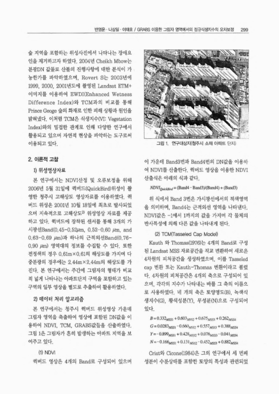
| GRABS 이용한 그림자 영역에서의 정규식생지수의 오차보정 :청주시를 대상으로 | 반영운 ;나상일 ;이태호 | pp.297-305 |
|
보기 |
| 상수관망 모형의 비교 분석 연구 | 김준현 ;Natalia Yakunina | pp.307-314 |
|
보기 |
| 지리정보시스템 기반의 상수관망 모델링 시스템 연구 | 김준현 ;Natalia Yakunina | pp.315-321 |
|
보기 |
| 부산지역 내륙과 해안의 PM_10_ 중의 금속농도와 이온농도 특성 | 전병일 ;황용식 ;오광중 | pp.323-333 |
|
보기 |
| 바다골재채취에 따른 환경영향 스코핑과 제도개선 | 이대인 ;엄기혁 ;전경암 ;김귀영 | pp.335-345 |
|
보기 |
| 개발사업에 따른 조류종 영향평가모형 개발 및 적용 | 이동근 ;김은영 ;이은재 ;송원경 | pp.347-356 |
|
보기 |
| 우리나라 바다골재채취 및 협의제도 현황 평가 | 이대인 ;박달수 ;엄기혁 ;김귀영 | pp.357-365 |
|
보기 |
| 번호 | 참고문헌 | 국회도서관 소장유무 |
|---|---|---|
| 1 | Mutual Adjustment of Oceanographic Measurements from Ieodo Station and Satellite Data | 소장 |
| 2 | 김원주, 남기덕, 박정화, 1999, Land Cover Classification Based on the Phenology of Korea Using NOAA-AVHRR, 대한원격탐사학회 Proceedings of International Symposium on Remote Sensing 1999(1999.11) pp.439-442. | 미소장 |
| 3 | 박종화, 김진수, 나상일, 2006, Landsat 영상을 이용한 여름철 청주지역의 토지피복과 지표면 온도와의 관계분석, 한국농공학회, 48(5), 39-48. | 미소장 |
| 4 | 손홍규, 윤공현, 이동천, 2003, 컬러항공사진에서 그림자효과 보정에 관한 연구, 한국GIS학회 2003년 춘계학술대회 논문집. | 미소장 |
| 5 | 이규성, 1997, 인공위성 레이더 영상자료에 있어서 지형효과 저감을 위한 방사보정, 대한원격탐사학회, 13(1), 57-73. | 미소장 |
| 6 | Spectral indices and fire behavior simulation for fire risk assessment in savanna ecosystems  |
미소장 |
| 7 | Coops, N. C., Johnson, M., Wulder, M. A., and White, J. C., 2006, Assessment of QuickBird high spatial resolution imagery to detect red attack damage due to mountain pine beetle infestation, Remote Sensing of Environment, 103(1), 67-80. | 미소장 |
| 8 | The Tasseled Cap de-mystified |
미소장 |
| 9 | James H. Horne, 2003, A tasseled cap transformation for IKONOS images, ASPRS 2003 Annual Conference Proceedings. | 미소장 |
| 10 | Jensen, J. R., 2000, Remote Sensing of the Environment: An Earth Resource perspective, Prentice Hall. | 미소장 |
| 11 | Jordi Inglada, 2007, Automatic recognition of man-made objects in high resolution optical remote s sensing images. | 미소장 |
| 12 | Kauth, R. J. and G. S. Thomas, 1976, The Tasseled Cap - A Graphic Description of the Spectral-Temporal Development of Agricultural Crops as Seen by Landsat, Proceedings, Machine Processing of Remotely Sensed Data, West Kafayette, IN: Laboratory for the Applications of Remote Sensing, 41-51. | 미소장 |
| 13 | Rouse J. W., Haas R. H., Schell J. A., and Deering D. W., 1974, Monitoring Vegetation Systems in the Great Plains with ERTS, Proceedings, Third Earth Resources Technology Satellite-1 Symposium, Greenbelt : NASA SP-351, 310-317. | 미소장 |
| 14 | Rouse, J. W., Haas Jr., R. H., Schell, J. A., and Deering, D. W., 1974. Monitoring Vegetation system in the Great Plains with ERTS. In:NASA SP-351, 3rd ERTS-1 Symposium, Washington, DC, pp. 09-317. | 미소장 |
| 15 | Sensitivity of the thematic mapper enhanced wetness difference index to detect mountain pine beetle red-attack damage |
미소장 |
| 16 | Comparison of time series tasseled cap wetness and the normalized difference moisture index in detecting forest disturbances |
미소장 |
| 17 | Comparison of petiole nitrate concentrations, SPAD chlorophyll readings, and QuickBird satellite imagery in detecting nitrogen status of potato canopies |
미소장 |
| 18 | Assessing broadband vegetation indices and QuickBird data in estimating leaf area index of corn and potato canopies |
미소장 |
*표시는 필수 입력사항입니다.
| 전화번호 |
|---|
| 기사명 | 저자명 | 페이지 | 원문 | 기사목차 |
|---|
| 번호 | 발행일자 | 권호명 | 제본정보 | 자료실 | 원문 | 신청 페이지 |
|---|
도서위치안내: 정기간행물실(524호) / 서가번호: 국내15
2021년 이전 정기간행물은 온라인 신청(원문 구축 자료는 원문 이용)

우편복사 목록담기를 완료하였습니다.
*표시는 필수 입력사항입니다.
저장 되었습니다.
